Plain-language summary
- What it solves
- When Etna is active, the useful data sits with different institutions in different formats.
- Who it can serve
- Anyone following volcanic activity, and anyone studying how heterogeneous public sources combine.
- What it produces
- A card combining thermal, seismic and high-altitude wind data, with two indicative 12-hour trajectories.
Move from a public event to a traceable geospatial picture without presenting it as an official alert.
3 · What it produces
Vertical card with ~700 and 500 hPa trajectories, corridors, regime, thermal/seismic context and safety gate.
How to read the latest output: Lines follow forecast winds at two levels; bands are indicative corridors. They do not represent concentration, deposition or hazard.
4 · How it works
From sources to output.
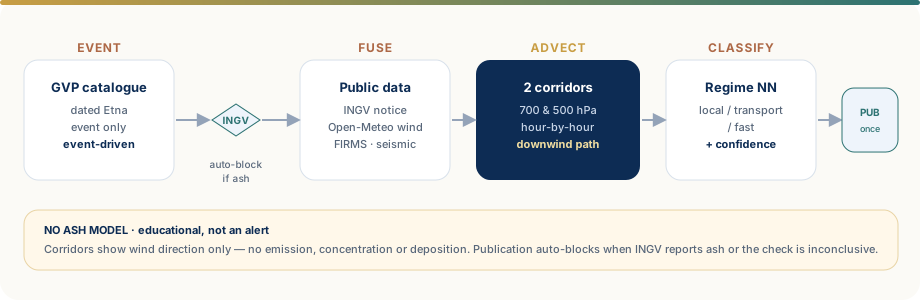
1New event
2INGV gate
3Multi-data
42-level winds
5Trajectories
6Publication
5 · Data used
| Source | Variable | Frequency | Limitation |
|---|---|---|---|
| Smithsonian GVP | Public dated Etna event | Every check | Feed delay and granularity |
| INGV/OE | Official notices and safety check | Every event | Conservative parsing; uncertainty blocks |
| NASA FIRMS VIIRS | 24-hour thermal anomalies | Every event | Thermal proxy, not proof of ash |
| Earthquake catalogue | 24-hour events and magnitude | Every event | Coverage and thresholds |
| Open-Meteo | Hourly winds at 700 and 500 hPa | Every event | Interpolated field; not an ash model |
Models and rules
Hourly Lagrangian advection converts wind speed and direction into geographic displacement. Two pressure levels show vertical differences; mean speed, variability and directional shear feed an MLP regime classifier. DBSCAN groups FIRMS anomalies; Isolation Forest can flag unusual configurations.
Controls
Fail-closed official safety gate, freshness, provenance, stale-image checks, exact and perceptual hashes, anti-duplicate state and two independent bilingual posts.
Results and metrics
Run outcomes (published, skipped, blocked), source availability and duplicates prevented. No operational dispersion skill is claimed.
Limits
No source term, real plume height, grain size, turbulence, sedimentation, deposition, concentration, visibility or aviation hazard.
Possible applications of the pattern
Event and geospatial fusion
Possible applications: event-driven workflows for environmental phenomena, distributed infrastructure or territorial monitoring. Observations, simulations and official communications must remain separate.
Transferable components
Research questions
- uncertainty propagation
- comparison with dispersion models
- event-trigger quality
- regime validation
Workflow technical dossier
IMPLEMENTEDDescribes behaviour present in the workflow.EXTENSIONIndicates a possible check or evolution, not an operating feature.
Implementation detail and assessment criteria.
This section connects the visible output to data-engineering, modelling, validation and delivery choices present in the repository.
Architecture and data
- Trigger on a new dated Etna event in the GVP feed, followed by a fail-closed INGV/OE official gate.
- Fusion of seismicity, FIRMS hotspots and Open-Meteo winds; typed objects with Pydantic.
- JSON state with event, fingerprint, image hash and URIs of two standalone publications.
Features and methods
- Hourly trajectory integration through Lagrangian advection at roughly 700 and 500 hPa.
- Indicative corridors derived from central paths; shear and geometry feed regime classification.
- DBSCAN for FIRMS clusters, Isolation Forest for unusual configurations and MLPClassifier/optional PyTorch.
Validation and failure modes
- Checks on event age, official source, current data, timestamps and non-reuse of previous images.
- Tests for safety, captions, events, seismicity, guards, release contracts and bilingual publishing.
- The method does not model concentration, sedimentation, grain size or aviation hazard.
Runtime and delivery
- Installable Python package with Hatch CLI, pytest and Ruff; dependencies locked in uv.lock.
- Beautiful Soup/pypdf, requests, pandas, scikit-learn, matplotlib/Pillow and GitHub Actions.
10 · Operating timeline
Operating timeline
- Status: Active · event-driven
- Frequency: Checked every 6 hours; posted only for a valid new event
- Page updated: July 2026
11 · Technical detail
Method and assumptions
Hourly Lagrangian advection converts wind speed and direction into geographic displacement. Two pressure levels show vertical differences; mean speed, variability and directional shear feed an MLP regime classifier. DBSCAN groups FIRMS anomalies; Isolation Forest can flag unusual configurations.
Main failure modes
No source term, real plume height, grain size, turbulence, sedimentation, deposition, concentration, visibility or aviation hazard.
Publication governance
Fail-closed official safety gate, freshness, provenance, stale-image checks, exact and perceptual hashes, anti-duplicate state and two independent bilingual posts.
See real outputs
The Publications page reads the public Bluesky feed and shows up to three recent runs, including multiple images in one post.
Potential transferability
Have a problem similar to Satellite?
A first discussion can start from the objective, available data and success criterion without sending confidential information. A result observed here is not assumed to transfer automatically to another context.